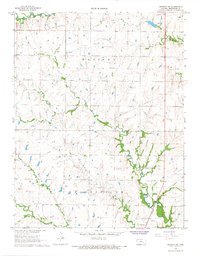
1967 Map of Madison SW
USGS Topo · Published 1968About this map
Madison Oil Field and the Janesville Field dominate this mid-century landscape in Greenwood County, where the petroleum industry is etched into the terrain via numerous Oil Wells and pipelines. The Atchison Topeka and Santa Fe railroad runs north-to-south through the eastern portion of the map, following the winding course of Willow Creek. This era of development is balanced by long-established landmarks including the Woods Cem and Prairie Chapel Cem, offering specific points of interest for genealogical research.
Find a feature on this map
16 named features on this map. Tap any name to fly to it.
Don’t see what you’re looking for? This feature index may not catch every label — zoom into the map to look around manually.
Map Details
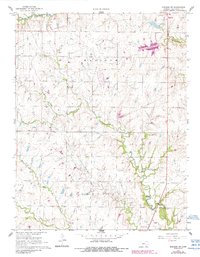
Editions of this 1967 Madison SW Map
2 editions found
Other maps of this area

1885 · Eureka
USGS Topo · 1:125,000

1888 · Emporia
USGS Topo · 1:125,000

1888 · Eureka
USGS Topo · 1:125,000

1894 · Emporia
USGS Topo · 1:125,000
1894 · Eureka
USGS Topo · 1:125,000

1955 · Wichita
USGS Topo · 1:250,000

1955 · Hutchinson
USGS Topo · 1:250,000

1958 · Wichita
USGS Topo · 1:250,000

1959 · Hutchinson
USGS Topo · 1:250,000
1967 · Thrall
USGS Topo · 1:24,000