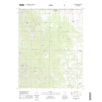
2020 Map of Eureka Springs
USGS Topo · Published 2020About this map
Eureka Springs anchors this survey of Carroll County, showcasing the town's unique geography nestled around Magnetic Spring and the base of Mt Oberammergau. The landscape transitions from the urbanized streets of the resort town to the developed vacation community of Holiday Island along the shores of Table Rock Lake. A network of winding country roads, such as Co Rd 230 and Carroll 2663 Rd, connects disparate settlements like Oak Hill, Pleasant Ridge, and Grandview. Notable for local history and genealogy, the map identifies several burial grounds including Eureka Springs Cem and the more remote Gaskins Switch Cem. The presence of Silver Wings Field and the larger Carroll County Airport underscores the region's accessibility, while the Kings River and Osage Creek define the natural drainage patterns that have shaped this Ozark highland for generations.
Find a feature on this map
88 named features on this map. Tap any name to fly to it.
Don’t see what you’re looking for? This feature index may not catch every label — zoom into the map to look around manually.
Map Details
Editions of this 2020 Eureka Springs Map
This is the sole edition of this map. No revisions or reprints were ever made.
Other maps of this area

1900 · Eureka Springs
USGS Topo · 1:125,000

1901 · Eureka Springs
USGS Topo · 1:125,000

1927 · Shell Knob
USGS Topo · 1:62,500

1937 · Cassville
USGS Topo · 1:48,000

1944 · Cassville
USGS Topo · 1:62,500

1945 · Harrison
USGS Topo · 1:250,000

1949 · Harrison
USGS Topo · 1:250,000

1950 · Shell Knob
USGS Topo · 1:62,500

1954 · Harrison
USGS Topo · 1:250,000

1957 · Mundell
USGS Topo · 1:24,000