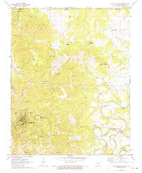
1972 Map of Eureka Springs
USGS Topo · Published 1973About this map
Eureka Springs anchor this Carroll County landscape, where the sharp relief of the Ozark plateau meets significant landmarks of faith and geology. The map details the steep topography surrounding Mount Oberammergau, home to the massive Christ of the Ozarks statue and the nearby Magnetic Spring. Just north of the city, the winding Kings River and Osage Creek carve deep valleys through the limestone, revealing sites like Onyx Cave and the prominent Pivot Rock.
Find a feature on this map
45 named features on this map. Tap any name to fly to it.
Don’t see what you’re looking for? This feature index may not catch every label — zoom into the map to look around manually.
Map Details
Editions of this 1972 Eureka Springs Map
This is the sole edition of this map. No revisions or reprints were ever made.
Other maps of this area

1900 · Eureka Springs
USGS Topo · 1:125,000

1901 · Eureka Springs
USGS Topo · 1:125,000

1927 · Shell Knob
USGS Topo · 1:62,500

1937 · Cassville
USGS Topo · 1:48,000

1944 · Cassville
USGS Topo · 1:62,500

1945 · Harrison
USGS Topo · 1:250,000

1949 · Harrison
USGS Topo · 1:250,000

1950 · Shell Knob
USGS Topo · 1:62,500

1954 · Harrison
USGS Topo · 1:250,000

1957 · Mundell
USGS Topo · 1:24,000