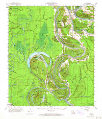
1960 Map of Eva
USGS Topo · Published 1964About this map
Black River meanders through a dense network of swampy brakes and bayous along the borders of Catahoula and Concordia Parish at the turn of the 1960s. This survey records an active extraction economy, highlighting extensive petroleum operations such as the Larto Lake Oil Field and the South Larto Lake Oil Field that pepper the landscape with wells and access roads. The alluvial character of the terrain is evident in the numerous oxbow lakes and sloughs, including Cynthia Bayou Lake and Black River Lake, which dictate the placement of small rural communities like Mayna and New Era. Evidence of earlier history and local genealogy is scattered throughout the bottomlands, from the ancient Indian Mound to family landmarks like Palo Alto Cem and Hedrick Cem. An Old Railroad Grade cuts across the southeast, marking a former transportation corridor that once served the timber or rail needs of these river settlements.
Find a feature on this map
142 named features on this map. Tap any name to fly to it.
Don’t see what you’re looking for? This feature index may not catch every label — zoom into the map to look around manually.
Map Details
Editions of this 1960 Eva Map
3 editions found
Other maps of this area

1935 · Tooleys
USGS Topo · 1:62,500

1939 · Red Gum
USGS Topo · 1:62,500

1939 · Artonish
USGS Topo · 1:62,500

1939 · Deer Park
USGS Topo · 1:62,500

1940 · Marksville
USGS Topo · 1:62,500

1941 · Manifest
USGS Topo · 1:62,500

1941 · Jena
USGS Topo · 1:62,500

1941 · Voorhies
USGS Topo · 1:62,500

1941 · Buckeye
USGS Topo · 1:62,500

1941 · Tooleys
USGS Topo · 1:62,500