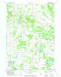
1972 Map of Evans
USGS Topo · Published 1974About this map
Glacial lakes and small rural settlements define this northern Kent County landscape as it appeared in the early 1970s. The area is characterized by a high density of water bodies, including the large Wabasis Lake and the interconnected waters of Myers Lake, Stoner Lake, and Tamarack Lake. The map reveals a transition in transportation, showing the Old Railroad Grade passing through the hamlets of Harvard and Evans, while the surrounding townships of Nelson, Spencer, Courtland, and Oakfield maintain their agrarian character. Genealogists will find significant value in the numerous documented burial sites such as East Nelson Cem, Oakfield Cem, and Courtland Cem, which often sit near local landmarks like the East Nelson Church or the United Methodist Church. This detailed survey captures a moment when traditional township centers and rural schools remained the primary anchors for the community.
Find a feature on this map
63 named features on this map. Tap any name to fly to it.
Don’t see what you’re looking for? This feature index may not catch every label — zoom into the map to look around manually.
Map Details
Editions of this 1972 Evans Map
2 editions found
Other maps of this area

1918 · Cedar Springs
USGS Topo · 1:62,500

1943 · Cedar Springs
USGS Topo · 1:62,500

1954 · Midland
USGS Topo · 1:250,000

1958 · Midland
USGS Topo · 1:250,000

1958 · Sand Lake
USGS Topo · 1:62,500

1959 · Midland
USGS Topo · 1:250,000

1959 · Howard City
USGS Topo · 1:62,500

1966 · Midland
USGS Topo · 1:250,000

1967 · Cedar Springs
USGS Topo · 1:24,000
1967 · Rockford
USGS Topo · 1:24,000