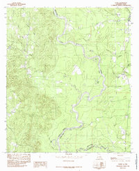
1984 Map of Evans
USGS Topo · Published 1985About this map
The Sabine River carves a winding path along the state boundary between Texas and Louisiana in this mid-1980s survey. The landscape is defined by the river's dynamic history, evidenced by oxbows and cutoffs such as Evans Old River, Joe Lake, and Horseshoe Lake. Small settlements and family landmarks are scattered throughout the region, including the rural communities of Evans, Almadane, and Stringtown.
Find a feature on this map
23 named features on this map. Tap any name to fly to it.
Don’t see what you’re looking for? This feature index may not catch every label — zoom into the map to look around manually.
Map Details
Editions of this 1984 Evans Map
This is the sole edition of this map. No revisions or reprints were ever made.
Other maps of this area

1941 · Leesville
USGS Topo · 1:62,500

1943 · Leesville
USGS Topo · 1:62,500

1944 · Wiergate
USGS Topo · 1:62,500

1946 · Leesville
USGS Topo · 1:62,500

1946 · Merryville
USGS Topo · 1:31,680

1947 · Pujo
USGS Topo · 1:31,680

1947 · Knight
USGS Topo · 1:31,680

1948 · Leesville
USGS Topo · 1:62,500

1948 · Wiergate
USGS Topo · 1:62,500

1949 · Evans
USGS Topo · 1:31,680