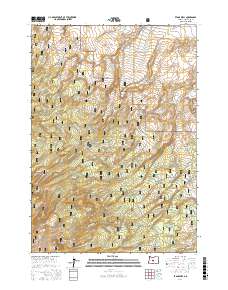
2017 Map of Evans Well
USGS Topo · Published 2017About this map
Deschutes National Forest encompasses the vast majority of this landscape, dominated by the northern reaches of the Newberry Volcano. The terrain is characterized by a complex network of forest roads and off-highway vehicle trails, including Ohv #10 and Ohv #18, which weave through the volcanic slopes. In the northern section, the land descends toward the Millican Valley, where the namesake Evans Well is located. This area represents a critical intersection of high-desert recreation and geological study, where the structural remnants of past volcanic activity dictate the modern access routes. The density of trails such as Ohv #25 and Ohv #50 illustrates the conversion of the forest's working timber roads into a specialized recreational infrastructure by the early 21st century.
Find a feature on this map
53 named features on this map. Tap any name to fly to it.
Don’t see what you’re looking for? This feature index may not catch every label — zoom into the map to look around manually.
Map Details
Editions of this 2017 Evans Well Map
This is the sole edition of this map. No revisions or reprints were ever made.
Other maps of this area

1931 · Newberry Crater
USGS Topo · 1:125,000

1935 · Newberry Crater
USGS Topo · 1:125,000

1955 · Crescent
USGS Topo · 1:250,000

1957 · Crescent
USGS Topo · 1:250,000

1958 · Crescent
USGS Topo · 1:250,000
1967 · Horse Ridge
USGS Topo · 1:24,000
1967 · Evans Well
USGS Topo · 1:24,000
1967 · Fuzztail Butte
USGS Topo · 1:24,000
1967 · Kelsey Butte
USGS Topo · 1:24,000
1967 · Millican
USGS Topo · 1:24,000