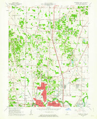
1961 Map of Evansville North
USGS Topo · Published 1963About this map
The expanding northern reaches of Evansville are captured during a period of significant post-war growth, showing the transformation of farmland into suburban developments. The map highlights a complex infrastructure network where the New York Central, Illinois Central, and Chicago and Eastern Illinois railroads intersect the landscape. Major aviation landmarks like Dress Memorial Airport and the smaller Skylane Airport signify the area's role as a regional transportation hub.
Find a feature on this map
138 named features on this map. Tap any name to fly to it.
Don’t see what you’re looking for? This feature index may not catch every label — zoom into the map to look around manually.
Map Details
Editions of this 1961 Evansville North Map
This is the sole edition of this map. No revisions or reprints were ever made.
Other maps of this area

1901 · Haubstadt
USGS Topo · 1:62,500

1902 · Ditney
USGS Topo · 1:125,000

1902 · Boonville
USGS Topo · 1:62,500

1903 · Haubstadt
USGS Topo · 1:62,500

1903 · Patoka
USGS Topo · 1:125,000

1905 · Newburg
USGS Topo · 1:62,500

1914 · Henderson
USGS Topo · 1:48,000

1916 · Henderson
USGS Topo · 1:62,500

1952 · Evansville
USGS Topo · 1:24,000

1952 · Newburgh
USGS Topo · 1:24,000