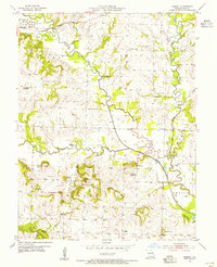
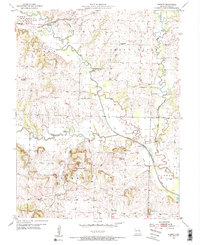
1953 Map of Everett
USGS Topo · Published 1955About this map
Everett and Austin anchor this rural Cass County landscape as it appeared in the early 1950s, defined by the winding course of the South Grand River. The river's influence is clear through the complex meanders and the Old Channel paths that trace its historical movement across the floodplain. Rural education and community life are well-documented here, featuring numerous country schools such as Hickory Grove Sch, Bybee Sch, and Rocky Point Sch, alongside several that were already marked as out of use, including Zion Sch (Abandoned). Distinctive topographic landmarks like Dolan Mound, Steen Mound, and Masters Hill rise above the river bottomlands, while a large Tank Farm in the northwest corner points to the area's mid-century infrastructure. Genealogists will find particular value in the location of the Burford Cem and the Grand River Ch situated near the river's bend.
Find a feature on this map
35 named features on this map. Tap any name to fly to it.
Don’t see what you’re looking for? This feature index may not catch every label — zoom into the map to look around manually.
Map Details
Editions of this 1953 Everett Map
2 editions found
Other maps of this area

1887 · Harrisonville
USGS Topo · 1:125,000

1887 · Olathe
USGS Topo · 1:125,000

1887 · Butler
USGS Topo · 1:125,000

1887 · Mound City
USGS Topo · 1:125,000

1892 · Harrisonville
USGS Topo · 1:125,000

1893 · Mound City
USGS Topo · 1:125,000

1893 · Olathe
USGS Topo · 1:125,000

1894 · Harrisonville
USGS Topo · 1:125,000

1894 · Butler
USGS Topo · 1:125,000

1947 · Lawrence
USGS Topo · 1:250,000