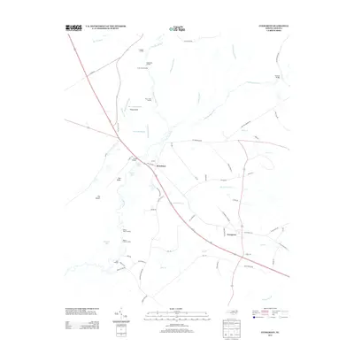
2013 Map of Evergreen
USGS Topo · Published 2013About this map
Lumber River meanders through the heart of this landscape, defining the rural character and transportation history of Columbus County. The river corridor is punctuated by numerous historic river access points such as Meadow Landing, Upper Buck Landing, and Parkers Lower Landing, which reflect the area's deep-rooted connection to the water. The settlements of Boardman and Evergreen serve as local hubs, connected by the corridor of Old Highway 74. The geography is further distinguished by a network of engineered waterways, including Big Swamp Canal and Stevens Canal, which reveal the intensive efforts to manage the wetlands for agriculture. Pockets of natural lakes, notably Smith Lake and Wild Cat Lake, are found alongside terrain features like Pea Ridge and The Islands, providing a detailed look at the complex interplay between the swampy lowlands and the higher ground chosen for settlement and transit.
Find a feature on this map
64 named features on this map. Tap any name to fly to it.
Don’t see what you’re looking for? This feature index may not catch every label — zoom into the map to look around manually.
Map Details
Editions of this 2013 Evergreen Map
This is the sole edition of this map. No revisions or reprints were ever made.
Other maps of this area

1943 · Pages Mill
USGS Topo · 1:62,500

1953 · Chadbourn
USGS Topo · 1:62,500

1953 · Florence
USGS Topo · 1:250,000

1954 · Florence
USGS Topo · 1:250,000

1957 · Bladenboro
USGS Topo · 1:62,500

1962 · Fair Bluff
USGS Topo · 1:24,000

1962 · Fairmont
USGS Topo · 1:24,000

1962 · Fair Bluff
USGS Topo · 1:62,500

1972 · Southwest Lumberton
USGS Topo · 1:24,000
1976 · Southwest Lumberton
USGS Topo · 1:24,000