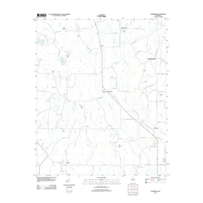
2012 Map of Evergreen
USGS Topo · Published 2012About this map
Ballardsville and the surrounding Itawamba County countryside are defined by a network of creeks and numerous small family burial grounds. The landscape is drained by the winding Boguefala Cr and Boguegaba Cr, which carve through the terrain south toward Evergreen. For genealogists, the map is remarkably dense with family-named landmarks and cemeteries, including the Bowlin Family Cem, Pettigrew-Ivy Family Cem, and the Orr-Patterson Family Cem. Near the western edge, Tombigbee State Park protects the area around Little Garrett Cr, while Lake Wilhelmina provides a significant water feature amidst the rural road network. Smaller settlements like Richmond and Shiloh serve as local anchors for the dispersed farming and residential community, connected by historic routes like Ballardsville Rd and Dorsey Evergreen Rd.
Find a feature on this map
127 named features on this map. Tap any name to fly to it.
Don’t see what you’re looking for? This feature index may not catch every label — zoom into the map to look around manually.
Map Details
Editions of this 2012 Evergreen Map
This is the sole edition of this map. No revisions or reprints were ever made.
Other maps of this area

1921 · Tupelo
USGS Topo · 1:48,000

1923 · Tupelo
USGS Topo · 1:62,500

1956 · Tupelo
USGS Topo · 1:250,000

1958 · Tupelo
USGS Topo · 1:250,000

1965 · Mooreville
USGS Topo · 1:24,000

1965 · Fulton
USGS Topo · 1:24,000

1966 · Smithville
USGS Topo · 1:24,000

1966 · Beans Ferry
USGS Topo · 1:24,000

1966 · Shannon
USGS Topo · 1:24,000
1966 · Nettleton
USGS Topo · 1:24,000