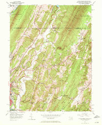
1949 Map of Evitts Creek
USGS Topo · Published 1972About this map
The Mason and Dixon Line serves as a prominent horizontal divider across this 1949 topographic landscape, marking the historic boundary between Pennsylvania and Maryland. To the south, the city of Cumberland and South Cumberland anchor the map's western edge, showing established neighborhoods, Constitution Park, and educational landmarks like Fort Hill High Sch. The region is defined by a series of north-south ridges including Shriver Ridge, Evitts Mountain, and Martin Mountain, which create deep valleys where small settlements like Dickens, Hazen, and Twiggtown persist alongside the drainage of Evitts Creek.
Find a feature on this map
66 named features on this map. Tap any name to fly to it.
Don’t see what you’re looking for? This feature index may not catch every label — zoom into the map to look around manually.
Map Details
Editions of this 1949 Evitts Creek Map
3 editions found
Other maps of this area

1898 · Frostburg
USGS Topo · 1:62,500

1899 · Flintstone
USGS Topo · 1:62,500

1900 · Flintstone
USGS Topo · 1:62,500

1901 · Frostburg
USGS Topo · 1:62,500

1908 · Frostburg
USGS Topo · 1:62,500

1923 · Berlin
USGS Topo · 1:48,000

1927 · Hyndman
USGS Topo · 1:62,500

1929 · Berlin
USGS Topo · 1:62,500

1931 · Hyndman
USGS Topo · 1:62,500

1944 · Hyndman
USGS Topo · 1:62,500