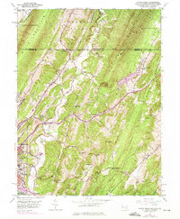
1949 Map of Evitts Creek
USGS Topo · Published 1975About this map
Cumberland and its northern outskirts are captured here at a moment of mid-century transition, where the heavy industry of the Baltimore and Ohio and Pennsylvania railroads meets the steep ridges of the Alleghenies. The landscape is defined by long, parallel geologic structures like Wills Mountain and Shriver Ridge, creating a series of narrow valleys that dictated early settlement and transport routes. Along the National Pike, small communities and landmarks like Wolfs Mill and the Mt Pleasant Ch serve as local anchors. To the north, the Mason and Dixon Line marks the political boundary with Pennsylvania near Cooks Mills. The 1974 photorevision highlights post-war growth, showing the development of South Cumberland and the Fort Hill High Sch campus alongside older landmarks like the Cumberland Country Club and Constitution Park.
Find a feature on this map
73 named features on this map. Tap any name to fly to it.
Don’t see what you’re looking for? This feature index may not catch every label — zoom into the map to look around manually.
Map Details
Editions of this 1949 Evitts Creek Map
3 editions found
Other maps of this area

1898 · Frostburg
USGS Topo · 1:62,500

1899 · Flintstone
USGS Topo · 1:62,500

1900 · Flintstone
USGS Topo · 1:62,500

1901 · Frostburg
USGS Topo · 1:62,500

1908 · Frostburg
USGS Topo · 1:62,500

1923 · Berlin
USGS Topo · 1:48,000

1927 · Hyndman
USGS Topo · 1:62,500

1929 · Berlin
USGS Topo · 1:62,500

1931 · Hyndman
USGS Topo · 1:62,500

1944 · Hyndman
USGS Topo · 1:62,500