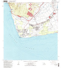
1983 Map of Ewa
USGS Topo · Published 1983About this map
Barbers Point Naval Air Station dominates the coastal plain of this Oahu landscape, where military installations and residential villages meet the industrial expansion of the early 1980s. The map illustrates a transitional period for the Ewa District, showing established communities like Tenney Village, Varona Village, and Renton Village alongside newer developments at Makakilo City. The presence of numerous pumping stations, flumes, and the Honouliuli Stream highlights the area's intensive water management, while industrial sites like the Oil Refinery and various quarries signify the economic shift away from traditional agriculture.
Find a feature on this map
56 named features on this map. Tap any name to fly to it.
Don’t see what you’re looking for? This feature index may not catch every label — zoom into the map to look around manually.
Map Details
Editions of this 1983 Ewa Map
2 editions found
Other maps of this area

1953 · Schofield Barracks
USGS Topo · 1:24,000

1953 · Ewa
USGS Topo · 1:24,000

1953 · Puuloa
USGS Topo · 1:24,000

1954 · Oahu
USGS Topo · 1:250,000

1954 · Waianae
USGS Topo · 1:24,000

1954 · Waipahu
USGS Topo · 1:24,000

1959 · Waipahu
USGS Topo · 1:24,000
1959 · Puuloa
USGS Topo · 1:24,000

1960 · Schofield Barracks
USGS Topo · 1:24,000

1961 · Oahu
USGS Topo · 1:250,000