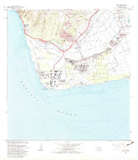
1983 Map of Ewa
USGS Topo · Published 1983About this map
Naval Air Station Barbers Point dominates the southwestern coast of Oahu in this early 1980s record of the Ewa Plain. The landscape reveals a complex transition between the established plantation era and modern industrial expansion, most notably at the Sugar Mill near Ewa and the sprawling Oil Refinery at Barbers Point. The residential pattern is highly localized, featuring a series of named plantation communities such as Tenney Village, Fernandez Village, and Renton Village, which stand in contrast to the newer residential development of Makakilo City rising onto the slopes of Puu Makakilo. The coastal edge is punctuated by specialized installations, from the Coast Guard Reservation to several beach parks and the critical Barbers Point Light. Inland, the terrain is defined by a series of deep gulches, including Waimanalo Gulch and Makaiva Gulch, which channel drainage toward the sea.
Find a feature on this map
61 named features on this map. Tap any name to fly to it.
Don’t see what you’re looking for? This feature index may not catch every label — zoom into the map to look around manually.
Map Details
Editions of this 1983 Ewa Map
2 editions found
Other maps of this area

1953 · Schofield Barracks
USGS Topo · 1:24,000

1953 · Ewa
USGS Topo · 1:24,000

1953 · Puuloa
USGS Topo · 1:24,000

1954 · Oahu
USGS Topo · 1:250,000

1954 · Waianae
USGS Topo · 1:24,000

1954 · Waipahu
USGS Topo · 1:24,000

1959 · Waipahu
USGS Topo · 1:24,000
1959 · Puuloa
USGS Topo · 1:24,000

1960 · Schofield Barracks
USGS Topo · 1:24,000

1961 · Oahu
USGS Topo · 1:250,000