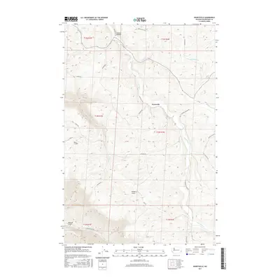
2017 Map of Ewartsville
USGS Topo · Published 2017About this map
Union Center and Ewartsville anchor this high-plateau landscape in Whitman County, where the agricultural geometry of the Palouse meets deep, branching drainages. The map reveals a sophisticated network of early transit routes like Wawawai Pullman Rd and Wawawai Grade Rd, which navigate the elevation drops toward the snake river breaks. Water defines the township boundaries, with Union Flat Cr and Almota Cr carving significant paths through the terrain. To the southwest, the dramatic relief of Wawawai Canyon and Buck Canyon marks the transition from rolling upland fields to the steep canyon lands. Local genealogy is well-supported by numerous family-named landmarks and roads, including Kamerrer Rd, Ryan Rd, and Klemgard Rd, which trace the legacy of early landholdings across these sections.
Find a feature on this map
31 named features on this map. Tap any name to fly to it.
Don’t see what you’re looking for? This feature index may not catch every label — zoom into the map to look around manually.
Map Details
Editions of this 2017 Ewartsville Map
This is the sole edition of this map. No revisions or reprints were ever made.
Other maps of this area

1910 · Pullman
USGS Topo · 1:125,000

1955 · Pullman
USGS Topo · 1:250,000

1958 · Pullman
USGS Topo · 1:250,000

1964 · Wilcox
USGS Topo · 1:24,000

1964 · Kirby
USGS Topo · 1:24,000

1964 · Colton
USGS Topo · 1:24,000
1964 · Albion
USGS Topo · 1:24,000

1964 · Colfax South
USGS Topo · 1:24,000

1964 · Ewartsville
USGS Topo · 1:24,000

1964 · Bishop
USGS Topo · 1:24,000