
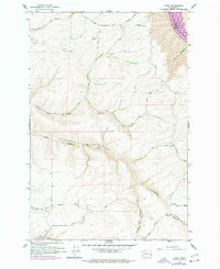
1964 Map of Kirby
USGS Topo · Published 1965About this map
The Snake River carves a deep path through the northeast corner of this landscape, marking the boundary between Whitman and Garfield Counties. This high-altitude agricultural region is defined by the broad Bell Plain and the Camas Prairie, where early 20th-century life centered around small hubs like Kirby and Crum. A network of steep gulches and canyons, including Kluge Canyon and Smith Gulch, descend toward the river, highlighting the physical challenges of moving goods in this terrain.
Find a feature on this map
26 named features on this map. Tap any name to fly to it.
Don’t see what you’re looking for? This feature index may not catch every label — zoom into the map to look around manually.
Map Details
Editions of this 1964 Kirby Map
2 editions found
Other maps of this area

1910 · Pullman
USGS Topo · 1:125,000

1937 · Pomeroy
USGS Topo · 1:96,000

1942 · Pomeroy
USGS Topo · 1:125,000

1943 · Peola
USGS Topo · 1:62,500

1946 · Peola
USGS Topo · 1:62,500

1950 · Penawawa
USGS Topo · 1:62,500

1955 · Pullman
USGS Topo · 1:250,000

1958 · Pullman
USGS Topo · 1:250,000

1964 · Ewartsville
USGS Topo · 1:24,000

1964 · Bishop
USGS Topo · 1:24,000