
1964 Map of Bishop
USGS Topo · Published 1965About this map
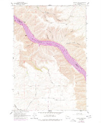
The Snake River carves a deep, winding passage through the plateau as it flows past the county line between Whitman and Garfield Counties. This 1964 field-checked survey reveals a river-oriented landscape before major modern transformations, where the small settlement of Bishop sits near the water's edge across from Bishop Bar. The rugged banks are punctuated by landmarks like Granite Point and Castle Rock, with O'Dell Rapids and Kelly Rapids indicating the natural force of the waterway.
Find a feature on this map
33 named features on this map. Tap any name to fly to it.
Don’t see what you’re looking for? This feature index may not catch every label — zoom into the map to look around manually.
Map Details
Editions of this 1964 Bishop Map
2 editions found
Other maps of this area

1910 · Pullman
USGS Topo · 1:125,000

1943 · Peola
USGS Topo · 1:62,500

1945 · Clarkston
USGS Topo · 1:62,500

1946 · Peola
USGS Topo · 1:62,500

1948 · Clarkston
USGS Topo · 1:62,500

1955 · Pullman
USGS Topo · 1:250,000

1958 · Pullman
USGS Topo · 1:250,000

1964 · Kirby
USGS Topo · 1:24,000

1964 · Colton
USGS Topo · 1:24,000

1964 · Ewartsville
USGS Topo · 1:24,000