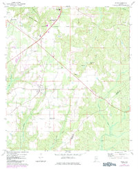
1972 Map of Excel
USGS Topo · Published 1984About this map
Excel and its surrounding Monroe County landscape are defined by a network of rural institutions and transport routes recorded in the early 1970s. The town serves as a local hub, anchored by the Excel Ch and the neighboring community of Halls Crossroads. To the north, the Monroeville Corporate Boundary encompasses key regional infrastructure including the Monroe Co Hospital, Monroe County Airport, and educational centers like Patrick Henry State Jr College and the Monroeville Academy.
Find a feature on this map
27 named features on this map. Tap any name to fly to it.
Don’t see what you’re looking for? This feature index may not catch every label — zoom into the map to look around manually.
Map Details
Editions of this 1972 Excel Map
2 editions found
Other maps of this area

1953 · Andalusia
USGS Topo · 1:250,000

1957 · Andalusia
USGS Topo · 1:250,000

1971 · Range
USGS Topo · 1:24,000

1971 · Burnt Corn
USGS Topo · 1:24,000

1971 · Repton
USGS Topo · 1:24,000

1972 · Monroeville
USGS Topo · 1:24,000

1972 · Frisco City
USGS Topo · 1:24,000

1972 · Frisco City SE
USGS Topo · 1:24,000

1972 · Uriah East
USGS Topo · 1:24,000

1972 · Excel
USGS Topo · 1:24,000