
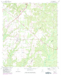
1972 Map of Excel
USGS Topo · Published 1974About this map
The town of Excel serves as a central hub in this early 1970s landscape, positioned just south of the Monroeville Corporate Boundary. The map illustrates a period of local expansion and institutional development, evidenced by the presence of Monroe County Airport, the Monroe Co Hospital, and educational landmarks like the Monroeville Academy and Patrick Henry State Jr College. This era shows a transition in transportation, where the St Louis - San Francisco and Louisville and Nashville railroads intersect the region's movement alongside an Old Railroad Grade. Rural life remains anchored by community landmarks such as Mt Olive Ch, Woodlawn Ch, and the settlement at Mexia Crossing. Numerous Gravel Pit and Sandpit operations scattered across the terrain point to the extractive industries supporting local road and infrastructure growth during this time.
Find a feature on this map
31 named features on this map. Tap any name to fly to it.
Don’t see what you’re looking for? This feature index may not catch every label — zoom into the map to look around manually.
Map Details
Editions of this 1972 Excel Map
2 editions found
Other maps of this area

1953 · Andalusia
USGS Topo · 1:250,000

1957 · Andalusia
USGS Topo · 1:250,000

1971 · Range
USGS Topo · 1:24,000

1971 · Burnt Corn
USGS Topo · 1:24,000

1971 · Repton
USGS Topo · 1:24,000

1972 · Monroeville
USGS Topo · 1:24,000

1972 · Frisco City
USGS Topo · 1:24,000

1972 · Frisco City SE
USGS Topo · 1:24,000

1972 · Uriah East
USGS Topo · 1:24,000

1972 · Mexia
USGS Topo · 1:24,000