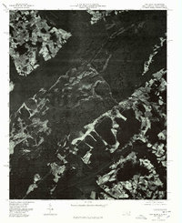
1976 Map of Fair Bluff
USGS Topo · Published 1978About this map
Lumber River snakes through the heart of this North Carolina landscape, its dark, winding course defining the dense wetlands between Fair Bluff and the South Carolina border. This orthophotoquad, derived from 1976 aerial photography, provides a stark visual record of the region's agricultural patterns and forested floodplains during the late twentieth century. In the southeast, the concentrated grid of Fair Bluff stands as the primary center of activity, while smaller settlements like Marietta and Causey anchor the surrounding rural expanse. The map’s photographic detail reveals the intricate patchwork of cleared fields and drainage networks that characterize this part of Columbus County, showing the proximity of human settlement to the river’s natural, meandering path.
Find a feature on this map
4 named features on this map. Tap any name to fly to it.
Don’t see what you’re looking for? This feature index may not catch every label — zoom into the map to look around manually.
Map Details
Editions of this 1976 Fair Bluff Map
This is the sole edition of this map. No revisions or reprints were ever made.
Other maps of this area

1943 · Pages Mill
USGS Topo · 1:62,500

1948 · Nichols
USGS Topo · 1:24,000

1949 · Duford
USGS Topo · 1:24,000

1950 · Nichols
USGS Topo · 1:24,000

1953 · Chadbourn
USGS Topo · 1:62,500

1953 · Florence
USGS Topo · 1:250,000

1954 · Florence
USGS Topo · 1:250,000

1962 · Fair Bluff
USGS Topo · 1:24,000

1962 · Fairmont
USGS Topo · 1:24,000

1962 · Lake View
USGS Topo · 1:24,000