
1950 Map of Nichols
USGS Topo · Published 1950About this map
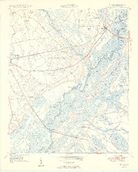
The Little Pee Dee River and its expansive Little Pee Dee River Swamp dominate this mid-century landscape, defining the boundary between Marion and Horry counties. This area is characterized by a dense network of blackwater features, including Black Creek, White Oak Lake, and numerous named bays such as Noel Bay and Hamish Bay. The Atlantic Coast Line railroad cuts through the terrain, connecting the larger community of Mullins to the town of Nichols in the northeast. This 1950 edition captures a rural South Carolina economy still deeply tied to the river and rail, where river crossings like Grice Ferry and the Sandy Bluff Bridge served as vital infrastructure for local transit between the sand hills and the fertile agricultural plots. The map is particularly rich for genealogical research, identifying numerous small schools and churches including Old Field School and Mill Creek Church.
Find a feature on this map
84 named features on this map. Tap any name to fly to it.
Don’t see what you’re looking for? This feature index may not catch every label — zoom into the map to look around manually.
Map Details
Editions of this 1950 Nichols Map
2 editions found
Other maps of this area

1943 · Pages Mill
USGS Topo · 1:62,500

1946 · Mullins
USGS Topo · 1:24,000

1947 · Centenary
USGS Topo · 1:24,000

1947 · Mullins
USGS Topo · 1:24,000

1948 · Galivants Ferry
USGS Topo · 1:24,000

1948 · Nichols
USGS Topo · 1:24,000

1948 · Bayboro
USGS Topo · 1:24,000

1949 · Bayboro
USGS Topo · 1:24,000

1949 · Duford
USGS Topo · 1:24,000

1950 · Galivants Ferry
USGS Topo · 1:24,000