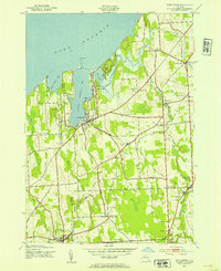
1943 Map of Fair Haven
USGS Topo · Published 1954About this map
Little Sodus Bay and the shoreline of Lake Ontario dominate this mid-century portrait of Cayuga County, where the village of Fair Haven serves as a central hub for maritime and rail activity. The 1943 field data shows a landscape transitioning from the era of rural school districts, such as School No 16 and School No 17, to one shaped by regional infrastructure. Two major rail lines, the Lehigh Valley and the New York Central, intersect the terrain, connecting inland points like Sterling Sta and Martville to the lakefront. Along the coast, the Fair Haven Beach State Park and the prominent Lighthouse at the bay entrance highlight the area's importance for both recreation and navigation. Genealogists will find a dense distribution of family-named burial grounds, including McArthur Cem and Overacre Cem, scattered across the rolling hills of Sterling and Victory.
Find a feature on this map
52 named features on this map. Tap any name to fly to it.
Don’t see what you’re looking for? This feature index may not catch every label — zoom into the map to look around manually.
Map Details
Editions of this 1943 Fair Haven Map
2 editions found
Other maps of this area

1900 · Oswego
USGS Topo · 1:62,500

1902 · Sodus Bay
USGS Topo · 1:62,500

1902 · Clyde
USGS Topo · 1:62,500

1902 · Weedsport
USGS Topo · 1:62,500

1943 · Oswego West
USGS Topo · 1:31,680

1943 · Cato
USGS Topo · 1:31,680

1943 · Hannibal
USGS Topo · 1:31,680

1943 · Fair Haven
USGS Topo · 1:31,680

1943 · Wolcott
USGS Topo · 1:31,680
1943 · Red Creek
USGS Topo · 1:31,680