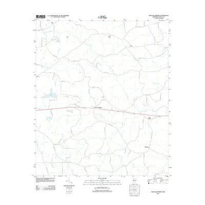
2012 Map of Fair Oak Springs
USGS Topo · Published 2012About this map
Little Fair River and its larger namesake, the Fair River, define the landscape of eastern Lincoln County in this contemporary survey. Small rural clusters and family-named landmarks are scattered throughout the territory, notably at Heucks Retreat in the northwest and Harmony in the southeast. For those researching local history or genealogy, the map identifies several burial sites including Smith Cem, Kees Cem, and Macedonia Cem. The central community of Fair Oak Springs sits along a primary east-west corridor, while legacy locations like Old Malcum suggest older settlement patterns. Higher elevations are marked by the Heucks Lookout Tower, overlooking a network of creeks such as Kees Cr and Richey Cr. The area maintains its character through a mix of small water bodies like Clarks Lake and Gravel Pit Lake, alongside numerous residential lanes that trace the undulating terrain of the Piney Woods.
Find a feature on this map
80 named features on this map. Tap any name to fly to it.
Don’t see what you’re looking for? This feature index may not catch every label — zoom into the map to look around manually.
Map Details
Editions of this 2012 Fair Oak Springs Map
This is the sole edition of this map. No revisions or reprints were ever made.
Other maps of this area

1953 · Natchez
USGS Topo · 1:250,000

1956 · Natchez
USGS Topo · 1:250,000

1959 · Natchez
USGS Topo · 1:250,000

1970 · Topeka
USGS Topo · 1:24,000

1970 · Nola
USGS Topo · 1:24,000

1971 · Oma
USGS Topo · 1:24,000

1972 · Fair Oak Springs
USGS Topo · 1:24,000

1972 · Ruth
USGS Topo · 1:24,000

1972 · Bogue Chitto
USGS Topo · 1:24,000
1972 · Stronghope
USGS Topo · 1:24,000