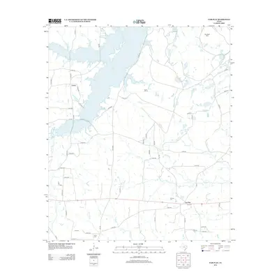
2013 Map of Fair Play
USGS Topo · Published 2013About this map
Martin Lake dominates the northwest corner of this Rusk County landscape, its irregular shoreline reaching toward the settlement of Liberty. The terrain transition is marked by The Sand Hills to the northeast and a dense network of creek branches that drain the interior. In the southeastern portion, the community of Fair Play serves as a local hub near several family burial sites including Harris Cem and Williams Cem. The map reveals a deeply rooted rural geography where local history is preserved in named landmarks like Sugar Hill Cem, Ross Cem, and Myers Cem. A complex system of county roads and farm-to-market routes, such as FM-1251 and FM-1798, connects these scattered homesteads and watercourse crossings, including the uniquely named Hainty Br and Buckner Cr.
Find a feature on this map
61 named features on this map. Tap any name to fly to it.
Don’t see what you’re looking for? This feature index may not catch every label — zoom into the map to look around manually.
Map Details
Editions of this 2013 Fair Play Map
This is the sole edition of this map. No revisions or reprints were ever made.
Other maps of this area

1956 · Tyler
USGS Topo · 1:250,000

1958 · Darco
USGS Topo · 1:62,500

1958 · Carthage
USGS Topo · 1:62,500

1958 · Tatum
USGS Topo · 1:62,500

1960 · Minden
USGS Topo · 1:62,500

1983 · Tatum
USGS Topo · 1:24,000

1983 · Harris Chapel
USGS Topo · 1:24,000
1983 · Church Hill
USGS Topo · 1:24,000

1983 · Long Branch
USGS Topo · 1:24,000

1983 · Fair Play
USGS Topo · 1:24,000