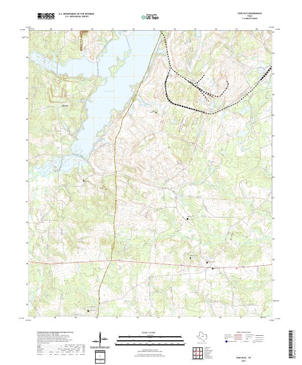
2022 Map of Fair Play
USGS Topo · Published 2022About this map
The boundary between Rusk and Panola Counties divides this landscape of eastern Texas, where the waters of Martin Lake dominate the northwest corner. This area is defined by a dense network of local watercourses, including Weir Creek, Buckner Creek, and Walkers Creek, which cut through the undulating terrain. The settlement of Liberty sits near the lakeshore, while the surrounding countryside is dotted with family and community burial grounds that provide a vital link for genealogical research. These sites, such as Sugar Hill Cemetery, Williams Cemetery, and Harris Cemetery, are dispersed across the quadrangle, often situated near minor county roads. The transport network relies on a mix of state FM roads and local routes like County Line Road, reflecting the rural character of the region as it transitions between the lakefront and the wooded interior.
Find a feature on this map
66 named features on this map. Tap any name to fly to it.
Don’t see what you’re looking for? This feature index may not catch every label — zoom into the map to look around manually.
Map Details
Editions of this 2022 Fair Play Map
This is the sole edition of this map. No revisions or reprints were ever made.
Other maps of this area

1956 · Tyler
USGS Topo · 1:250,000

1958 · Darco
USGS Topo · 1:62,500

1958 · Carthage
USGS Topo · 1:62,500

1958 · Tatum
USGS Topo · 1:62,500

1960 · Minden
USGS Topo · 1:62,500

1983 · Tatum
USGS Topo · 1:24,000

1983 · Harris Chapel
USGS Topo · 1:24,000
1983 · Church Hill
USGS Topo · 1:24,000

1983 · Long Branch
USGS Topo · 1:24,000

1983 · Fair Play
USGS Topo · 1:24,000