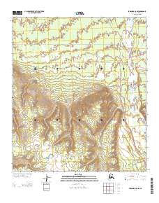
2013 Map of Fairbanks A-5 NW
USGS Topo · Published 2013About this map
The settlement of Rex sits at a critical junction in the Interior, where the Parks Hwy parallels the wide, braided course of the Nenana River. This 2013 topographic survey captures the meeting of modern transportation corridors and older wilderness routes, such as Sled Rd and the Rex-Anna Trl. The landscape transitions from the flat river valley into a series of drainages, most notably Birch Cr and Bear Cr, which carve through the rising elevation to the south.
Find a feature on this map
11 named features on this map. Tap any name to fly to it.
Don’t see what you’re looking for? This feature index may not catch every label — zoom into the map to look around manually.
Map Details
Editions of this 2013 Fairbanks A-5 NW Map
This is the sole edition of this map. No revisions or reprints were ever made.
Other maps of this area

1949 · Fairbanks B-5
USGS Topo · 1:63,360

1950 · Fairbanks
USGS Topo · 1:250,000

1950 · Fairbanks A-5
USGS Topo · 1:63,360

1950 · Fairbanks B-5
USGS Topo · 1:63,360

1951 · Fairbanks B-5
USGS Topo · 1:63,360

1951 · Fairbanks
USGS Topo · 1:250,000

1951 · Fairbanks A-5
USGS Topo · 1:63,360

1952 · Fairbanks A-6
USGS Topo · 1:63,360

1952 · Fairbanks
USGS Topo · 1:250,000
1953 · Fairbanks B-6
USGS Topo · 1:63,360