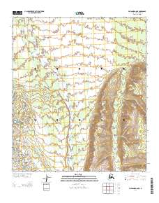
2013 Map of Fairbanks A-6 NE
USGS Topo · Published 2013About this map
Teklanika River dominates this interior landscape, weaving through the terrain in the Fairbanks A-6 NE quadrangle. The map reveals the characteristic braided nature of the river as it courses through the flatlands, transitioning into more defined topography toward the east. A single man-made trail, identified as Sled Rd, appears in the northeastern corner, providing a rare mark of human transit in this environment. The sparse nature of named features and roads emphasizes the isolation of this region within the Alaska-Denali Borough, where natural hydrology and elevation lines form the primary landmarks for navigators and researchers studying the northern wilderness.
Find a feature on this map
4 named features on this map. Tap any name to fly to it.
Don’t see what you’re looking for? This feature index may not catch every label — zoom into the map to look around manually.
Map Details
Editions of this 2013 Fairbanks A-6 NE Map
This is the sole edition of this map. No revisions or reprints were ever made.
Other maps of this area

1949 · Fairbanks B-5
USGS Topo · 1:63,360

1950 · Fairbanks
USGS Topo · 1:250,000

1950 · Fairbanks A-5
USGS Topo · 1:63,360

1950 · Fairbanks B-5
USGS Topo · 1:63,360

1951 · Fairbanks B-5
USGS Topo · 1:63,360

1951 · Fairbanks
USGS Topo · 1:250,000

1951 · Fairbanks A-5
USGS Topo · 1:63,360

1952 · Fairbanks A-6
USGS Topo · 1:63,360

1952 · Fairbanks
USGS Topo · 1:250,000
1953 · Fairbanks B-6
USGS Topo · 1:63,360