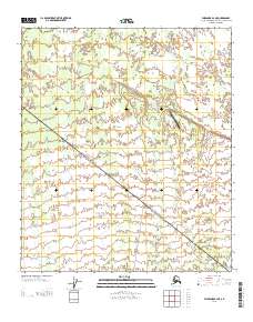
2013 Map of Fairbanks B-2 NE
USGS Topo · Published 2013About this map
Clear Creek Airport serves as a lone aviation landmark in this interior Alaskan landscape, positioned where the drainage of Clear Cr meets the low-lying terrain. The map captures a transition between the hydraulic patterns of Dry Cr and the structured grid of the Public Land Survey System, marked by the intersection of townships T 5 S and T 6 S. A traditional Sled Rd cuts through the southern sections of the quadrangle, representing a vital overland transport corridor used for winter movement through the Tanana Valley region. This 2013 survey illustrates the sparse, infrastructure-light nature of the Fairbanks North Star Borough, where development is clustered around specific access points like the airport while large tracts remain defined by their natural drainage systems.
Find a feature on this map
6 named features on this map. Tap any name to fly to it.
Don’t see what you’re looking for? This feature index may not catch every label — zoom into the map to look around manually.
Map Details
Editions of this 2013 Fairbanks B-2 NE Map
This is the sole edition of this map. No revisions or reprints were ever made.
Other maps of this area

1949 · Fairbanks C-1
USGS Topo · 1:63,360

1949 · Fairbanks C-2
USGS Topo · 1:63,360

1950 · Fairbanks
USGS Topo · 1:250,000

1950 · Fairbanks C-1
USGS Topo · 1:63,360

1950 · Fairbanks B-2
USGS Topo · 1:63,360

1950 · Fairbanks B-1
USGS Topo · 1:63,360
1951 · Fairbanks B-1
USGS Topo · 1:63,360
1951 · Fairbanks B-2
USGS Topo · 1:63,360

1951 · Fairbanks
USGS Topo · 1:250,000

1952 · Fairbanks C-2
USGS Topo · 1:63,360