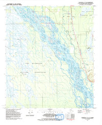
1992 Map of Fairbanks C-1 SE
USGS Topo · Published 1992About this map
The Tanana River dominates this Alaskan landscape, its braided channels and vast floodplains defining the local geography southeast of Fairbanks in the early 1990s. This interior region is heavily shaped by defense installations, with the Eielson Air Force Base and the Fort Wainwright Maneuver Area occupying significant portions of the terrain. The presence of the Eielson Alaska Long Period Array Research Site underscores the area's specialized scientific and military utility during the late Cold War era.
Find a feature on this map
17 named features on this map. Tap any name to fly to it.
Don’t see what you’re looking for? This feature index may not catch every label — zoom into the map to look around manually.
Map Details
Editions of this 1992 Fairbanks C-1 SE Map
This is the sole edition of this map. No revisions or reprints were ever made.
Other maps of this area

1949 · Big Delta B-6
USGS Topo · 1:63,360

1949 · Fairbanks C-1
USGS Topo · 1:63,360

1949 · Big Delta C-6
USGS Topo · 1:63,360

1950 · Fairbanks
USGS Topo · 1:250,000

1950 · Big Delta
USGS Topo · 1:250,000

1950 · Fairbanks C-1
USGS Topo · 1:63,360

1950 · Fairbanks B-1
USGS Topo · 1:63,360

1951 · Big Delta
USGS Topo · 1:250,000
1951 · Fairbanks B-1
USGS Topo · 1:63,360

1951 · Fairbanks
USGS Topo · 1:250,000