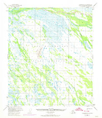
1949 Map of Fairbanks C-2
USGS Topo · Published 1974About this map
Fort Wainwright Military Reservation dominates this interior landscape, which was primarily defined by its wetland networks in the mid-20th century. The territory is characterized by a complex system of waterways, including Salchaket Slough in the north and the meandering courses of Clear Creek, McDonald Creek, and Willow Creek. A rare point of elevation, Clear Creek Butte, provides a significant topographical landmark amidst the surrounding marshes and low-relief terrain.
Find a feature on this map
9 named features on this map. Tap any name to fly to it.
Don’t see what you’re looking for? This feature index may not catch every label — zoom into the map to look around manually.
Map Details
Editions of this 1949 Fairbanks C-2 Map
3 editions found
Other maps of this area

1949 · Fairbanks D-1
USGS Topo · 1:62,500

1949 · Fairbanks D-2
USGS Topo · 1:62,500

1949 · Fairbanks C-1
USGS Topo · 1:63,360

1949 · Fairbanks D-3
USGS Topo · 1:63,360

1949 · Fairbanks C-2
USGS Topo · 1:63,360

1949 · Fairbanks B-3
USGS Topo · 1:63,360

1950 · Fairbanks
USGS Topo · 1:250,000

1950 · Fairbanks C-3
USGS Topo · 1:63,360

1950 · Fairbanks C-1
USGS Topo · 1:63,360

1950 · Fairbanks B-2
USGS Topo · 1:63,360