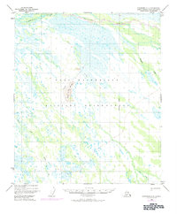
1949 Map of Fairbanks C-2
USGS Topo · Published 1984About this map
The Fort Wainwright Military Reservation dominates this section of the Interior, showcasing a landscape of complex waterways and wetlands north of the Tanana River. Photogrammetric data from 1949 and subsequent 1972 revisions reveal a shifting network of drainage, where the Salchaket Slough and meandering Clear Creek define the low-lying terrain. The prominent Clear Creek Butte serves as a singular point of elevation amidst the surrounding flats, providing a geographical anchor for the military reserve.
Find a feature on this map
9 named features on this map. Tap any name to fly to it.
Don’t see what you’re looking for? This feature index may not catch every label — zoom into the map to look around manually.
Map Details
Editions of this 1949 Fairbanks C-2 Map
3 editions found
Other maps of this area

1949 · Fairbanks D-1
USGS Topo · 1:62,500

1949 · Fairbanks D-2
USGS Topo · 1:62,500

1949 · Fairbanks C-1
USGS Topo · 1:63,360

1949 · Fairbanks D-3
USGS Topo · 1:63,360

1949 · Fairbanks C-2
USGS Topo · 1:63,360

1949 · Fairbanks B-3
USGS Topo · 1:63,360

1950 · Fairbanks
USGS Topo · 1:250,000

1950 · Fairbanks C-3
USGS Topo · 1:63,360

1950 · Fairbanks C-1
USGS Topo · 1:63,360

1950 · Fairbanks B-2
USGS Topo · 1:63,360