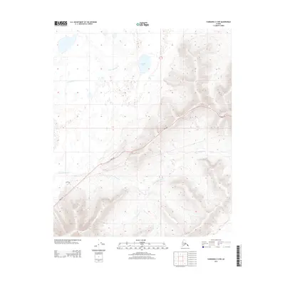
2013 Map of Fairbanks C-4 NW
USGS Topo · Published 2013About this map
Parks Hwy cuts a distinct path through the interior Alaskan landscape in this 2013 survey, serving as the primary corridor between the higher elevations and the drainage basins below. The terrain is defined by the winding course of Little Goldstream Cr, which meanders through a complex of wetlands and small ponds in the northwestern portion of the quadrangle. This area is characterized by the presence of Twomile Lake, a prominent water body situated amidst a network of smaller, unnamed ponds that suggest a seasonal or permafrost-affected hydrology. While primarily undeveloped, the area shows signs of local access via Kiglowa Dr near the southern boundary. The map provides a clear look at the transitional topography where the valley floor meets the rising ridges, providing an essential record of the natural drainage patterns and the infrastructure connecting this portion of the Unorganized Borough.
Find a feature on this map
7 named features on this map. Tap any name to fly to it.
Don’t see what you’re looking for? This feature index may not catch every label — zoom into the map to look around manually.
Map Details
Editions of this 2013 Fairbanks C-4 NW Map
This is the sole edition of this map. No revisions or reprints were ever made.
Other maps of this area

1949 · Fairbanks D-4
USGS Topo · 1:63,360

1950 · Fairbanks
USGS Topo · 1:250,000

1950 · Fairbanks C-5
USGS Topo · 1:63,360

1950 · Fairbanks C-4
USGS Topo · 1:63,360

1950 · Fairbanks D-5
USGS Topo · 1:63,360

1951 · Fairbanks
USGS Topo · 1:250,000

1952 · Fairbanks C-4
USGS Topo · 1:63,360

1952 · Fairbanks D-4
USGS Topo · 1:63,360
1952 · Fairbanks C-5
USGS Topo · 1:63,360

1952 · Fairbanks
USGS Topo · 1:250,000