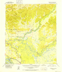
1952 Map of Fairbanks D-1
USGS Topo · Published 1952About this map
The Little Chena River and the meandering Chena River dominate this interior Alaskan landscape, shown here just as post-war infrastructure was expanding across the Fourth Judicial Division. Near the southern edge of the survey, the Alaska Railroad and the Alaska Richardson Highway provide critical transport links, running parallel to the Tanana River and passing a designated US Military Reservation. The map reveals a transition from the rugged upland drainages of Monte Cristo Cr and Yellow Pup Creek to the broad, marshy floodplains characterized by numerous unnamed sloughs and seasonal cabins. Early overland travel is evidenced by the network of winter-dependent routes like the Iowa Sled Road and Sled Road, which connected isolated homesteads and mining prospects long before paved networks were established. Notable local landmarks such as Lakloey Hill and Browns Hill rise above the complex waterway systems of Mullen Slough.
Find a feature on this map
42 named features on this map. Tap any name to fly to it.
Don’t see what you’re looking for? This feature index may not catch every label — zoom into the map to look around manually.
Map Details
Editions of this 1952 Fairbanks D-1 Map
This is the sole edition of this map. No revisions or reprints were ever made.
Other maps of this area

1945 · Livengood
USGS Topo · 1:250,000

1949 · Fairbanks D-1
USGS Topo · 1:62,500

1949 · Fairbanks D-2
USGS Topo · 1:62,500

1949 · Fairbanks C-1
USGS Topo · 1:63,360

1949 · Big Delta C-6
USGS Topo · 1:63,360

1949 · Fairbanks C-2
USGS Topo · 1:63,360

1950 · Fairbanks
USGS Topo · 1:250,000

1950 · Big Delta
USGS Topo · 1:250,000

1950 · Big Delta D-6
USGS Topo · 1:63,360

1950 · Fairbanks C-1
USGS Topo · 1:63,360