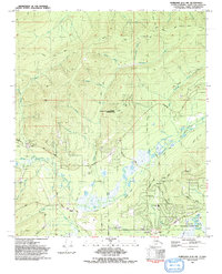
1992 Map of Fairbanks D-2 NW
USGS Topo · Published 1992About this map
Murphy Dome anchors the northwest corner of this sub-arctic landscape, where a network of trails and roads like Old Murphy Dome Road and Spinach Creek Road connect scattered mining prospects and research installations. The Eielson Alaska Long Period Array Research Site occupies a central ridge, while the southern valley floor transitions into the more developed outskirts of the region. This area is defined by the winding course of Goldstream Creek and its many tributaries, including O'Connor Creek and Happy Creek. The presence of the Old Railroad Grade and several Gravel Pits reflects the area's industrial utility, while the Creamers Field State Migratory Waterfowl Refuge and the Northern Lights Memorial Cem mark significant local landmarks. The settlement of Dogpatch sits near the Fairbanks Country Club Golf Course, illustrating the suburban expansion north of the city center.
Find a feature on this map
59 named features on this map. Tap any name to fly to it.
Don’t see what you’re looking for? This feature index may not catch every label — zoom into the map to look around manually.
Map Details
Editions of this 1992 Fairbanks D-2 NW Map
2 editions found
Other maps of this area

1945 · Livengood
USGS Topo · 1:250,000

1949 · Fairbanks D-2
USGS Topo · 1:62,500

1949 · Fairbanks D-3
USGS Topo · 1:63,360

1950 · Fairbanks
USGS Topo · 1:250,000

1950 · Fairbanks D-3
USGS Topo · 1:63,360

1951 · Fairbanks
USGS Topo · 1:250,000

1951 · Livengood
USGS Topo · 1:250,000

1952 · Fairbanks D-2
USGS Topo · 1:63,360

1952 · Fairbanks D-3
USGS Topo · 1:63,360

1952 · Fairbanks
USGS Topo · 1:250,000