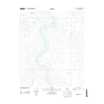
2013 Map of Fairbanks D-5 SE
USGS Topo · Published 2013About this map
The Tanana River dominates this interior Alaska landscape, carving a wide, braided path through a complex network of wetlands and secondary waterways. This region, documented in 2013, is characterized by a high concentration of Indigenous place names such as Gux Neetseel, Nooku Ch'edagheedhot Noo', and Teyh Tox Daghee'oyee, which highlight the enduring cultural geography of the area. These features are interspersed with descriptive English-named sloughs, including Sawmill Slough and Twentyfour Mile Slough, indicating a history of diverse navigation and land use. The presence of a Sled Rd cutting across the northern sections points to the specialized transportation methods required to traverse this marshy terrain, connecting Big Lake and Goldstream Cr to the larger river system during the winter months.
Find a feature on this map
13 named features on this map. Tap any name to fly to it.
Don’t see what you’re looking for? This feature index may not catch every label — zoom into the map to look around manually.
Map Details
Editions of this 2013 Fairbanks D-5 SE Map
This is the sole edition of this map. No revisions or reprints were ever made.
Other maps of this area

1949 · Fairbanks D-4
USGS Topo · 1:63,360

1950 · Fairbanks
USGS Topo · 1:250,000

1950 · Fairbanks C-5
USGS Topo · 1:63,360

1950 · Fairbanks C-4
USGS Topo · 1:63,360

1950 · Fairbanks D-5
USGS Topo · 1:63,360

1951 · Fairbanks
USGS Topo · 1:250,000

1952 · Fairbanks C-4
USGS Topo · 1:63,360

1952 · Fairbanks D-4
USGS Topo · 1:63,360
1952 · Fairbanks C-5
USGS Topo · 1:63,360

1952 · Fairbanks
USGS Topo · 1:250,000