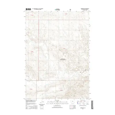
2015 Map of Fairburn NE
USGS Topo · Published 2015About this map
Buffalo Gap National Grassland dominates this section of the western South Dakota plains, where the drainage network of the Cheyenne River watershed begins to take shape. The landscape is defined by the carved paths of Red Shirt Creek and French Creek, with the latter joined by its tributary, S Fork French Creek, in the southern portion of the quadrangle. These watercourses have sculpted distinct terrain features such as Shorty Draw and Sheep Camp Draw, reflecting the erosional patterns of the northern Great Plains. Human presence is marked primarily by the path of E French Creek Rd, which provides access across the open grassland. This 2015 survey illustrates the modern management of public lands and the preservation of the native prairie environment in Custer County.
Find a feature on this map
14 named features on this map. Tap any name to fly to it.
Don’t see what you’re looking for? This feature index may not catch every label — zoom into the map to look around manually.
Map Details
Editions of this 2015 Fairburn NE Map
This is the sole edition of this map. No revisions or reprints were ever made.
Other maps of this area

1894 · Hermosa
USGS Topo · 1:125,000

1901 · Hermosa
USGS Topo · 1:125,000

1951 · Fairburn SE
USGS Topo · 1:24,000

1951 · Red Shirt
USGS Topo · 1:24,000

1951 · Red Shirt SW
USGS Topo · 1:24,000

1953 · Hermosa
USGS Topo · 1:24,000

1953 · Hermosa SE
USGS Topo · 1:24,000

1953 · Caputa SW
USGS Topo · 1:24,000

1955 · Hot Springs
USGS Topo · 1:250,000
1957 · Fairburn NE
USGS Topo · 1:24,000