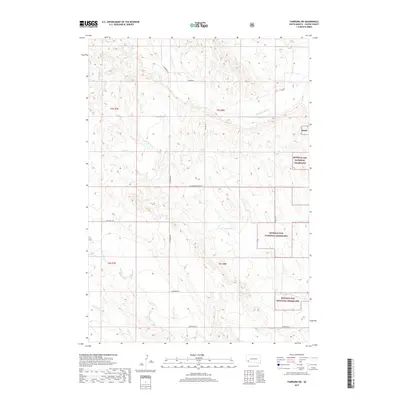
2017 Map of Fairburn SW
USGS Topo · Published 2017About this map
Buffalo Gap National Grassland dominates this portion of Custer County, South Dakota, where the prairie landscape is carved by seasonal watercourses and a sparse network of rural roads. The topography is defined by the winding paths of S Fork French Cr in the north and the expansive drainage of Cottonwood Cr and Lone Johnny Cr to the south. These creek beds dictate the local movement and land use, with tracks like the Cottonwood Cutoff and S Fairburn Rd connecting remote ranchlands. This survey illustrates the relationship between the open range and the public land boundaries of the Bgng, providing a clear view of the section lines and township divisions that have organized this territory since its initial settlement. Routes such as Old Hwy 79 S and Riverside Rd provide the primary access through this dry, high-plains environment.
Find a feature on this map
16 named features on this map. Tap any name to fly to it.
Don’t see what you’re looking for? This feature index may not catch every label — zoom into the map to look around manually.
Map Details
Editions of this 2017 Fairburn SW Map
This is the sole edition of this map. No revisions or reprints were ever made.
Other maps of this area

1894 · Hermosa
USGS Topo · 1:125,000

1896 · Oelrichs
USGS Topo · 1:125,000

1900 · Oelrichs
USGS Topo · 1:125,000

1901 · Hermosa
USGS Topo · 1:125,000

1950 · Buffalo Gap
USGS Topo · 1:24,000

1951 · Fairburn SE
USGS Topo · 1:24,000

1951 · Smithwick NE
USGS Topo · 1:24,000

1951 · Smithwick NW
USGS Topo · 1:24,000

1955 · Hot Springs
USGS Topo · 1:250,000
1957 · Fairburn NE
USGS Topo · 1:24,000