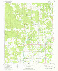
1979 Map of Fairdealing
USGS Topo · Published 1980About this map
Fairdealing serves as the primary settlement in this corner of the Missouri Ozarks, situated along the border of Ripley and Butler Counties. The landscape is defined by the winding course of the Little Black River, which flows past the SEMO Camp and Myers Lake towards the south. Evidence of the region's historical infrastructure is visible in the Old Railroad Grade near Taft and the network of rural churches and cemeteries that anchor these communities. Local landmarks like Lone Hill Lookout Tower and Ball Mill Bridge offer specific points of interest for those studying the area's mid-century development. The presence of the State Public Hunting Area and Wattle Landing Strip indicates a transition from traditional agricultural and timber use to modern recreation and light aviation by the late 1970s.
Find a feature on this map
46 named features on this map. Tap any name to fly to it.
Don’t see what you’re looking for? This feature index may not catch every label — zoom into the map to look around manually.
Map Details
Editions of this 1979 Fairdealing Map
2 editions found
Other maps of this area

1934 · Williamsville
USGS Topo · 1:48,000

1935 · Poplar Bluff
USGS Topo · 1:62,500

1935 · Acorn
USGS Topo · 1:62,500

1935 · Harviell
USGS Topo · 1:62,500

1939 · Poplar Bluff
USGS Topo · 1:62,500

1940 · Williamsville
USGS Topo · 1:62,500

1940 · Naylor
USGS Topo · 1:62,500

1944 · Naylor
USGS Topo · 1:62,500

1949 · Poplar Bluff
USGS Topo · 1:62,500

1957 · Poplar Bluff
USGS Topo · 1:250,000