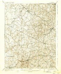
1915 Map of Fairfax
USGS Topo · Published 1936About this map
Fairfax and its surrounding countryside are captured here during a period of steady transition, where the rail-and-road network of Northern Virginia shaped the local economy. The Washington and Old Dominion railroad serves as a primary artery, passing through the established community of Herndon and the planned town of Wiehle. Further south, the Southern railroad connects Fairfax Sta and Clifton, facilitating travel and trade across the Fairfax and Prince William county line.
Find a feature on this map
67 named features on this map. Tap any name to fly to it.
Don’t see what you’re looking for? This feature index may not catch every label — zoom into the map to look around manually.
Map Details
Editions of this 1915 Fairfax Map
4 editions found

Other maps of this area

1884 · Harpers Ferry
USGS Topo · 1:125,000

1890 · Mt. Vernon
USGS Topo · 1:125,000

1891 · Harpers Ferry
USGS Topo · 1:125,000

1891 · Mt. Vernon
USGS Topo · 1:125,000

1893 · Frederick
USGS Topo · 1:125,000

1893 · Harpers Ferry
USGS Topo · 1:125,000

1894 · Warrenton
USGS Topo · 1:125,000

1894 · Frederick
USGS Topo · 1:125,000

1894 · Mt. Vernon
USGS Topo · 1:125,000

1897 · Mt. Vernon
USGS Topo · 1:125,000