
1915 Map of Fairfax
USGS Topo · Published 1915About this map
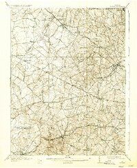
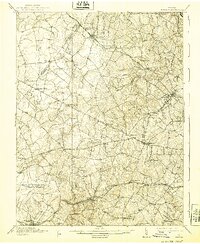
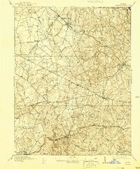
The Fairfax quadrangle, surveyed just before the First World War, reveals a landscape of independent villages and rural crossroads long before the arrival of the modern suburban sprawl. At this time, the county seat of Fairfax and the growing town of Herndon served as primary hubs, connected by a network of historic thoroughfares like the Little River Road and Braddock Road. The Washington and Old Dominion RR cuts through the northern reaches, supporting settlements such as Vienna and Wiehle, while the Southern RR serves the southern portion of the county through Clifton and Burke. Along the winding Bull Run, numerous crossings such as Balls Ford and Evans Ford mark the landscape, highlighting a era when river fords remained critical infrastructure for local transit between Fairfax and Prince William counties. Rural education and community life are grounded by landmarks like the Pleasant Valley School and Lee Chapel.
Find a feature on this map
71 named features on this map. Tap any name to fly to it.
Don’t see what you’re looking for? This feature index may not catch every label — zoom into the map to look around manually.
Map Details
Editions of this 1915 Fairfax Map
4 editions found
Other maps of this area

1884 · Harpers Ferry
USGS Topo · 1:125,000

1890 · Mt. Vernon
USGS Topo · 1:125,000

1891 · Harpers Ferry
USGS Topo · 1:125,000

1891 · Mt. Vernon
USGS Topo · 1:125,000

1893 · Frederick
USGS Topo · 1:125,000

1893 · Harpers Ferry
USGS Topo · 1:125,000

1894 · Warrenton
USGS Topo · 1:125,000

1894 · Frederick
USGS Topo · 1:125,000

1894 · Mt. Vernon
USGS Topo · 1:125,000

1897 · Mt. Vernon
USGS Topo · 1:125,000