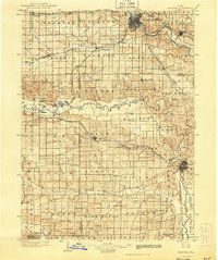
1903 Map of Fairfax
USGS Topo · Published 1943About this map
Iowa City and Cedar Rapids anchor the eastern edge of this region, which was surveyed during the final decades of the 19th century. The landscape is defined by the winding course of the Iowa River, which flows through several distinct communal settlements including West Amana, High Amana, Middle Amana, Amana, and East Amana. This concentration of Amana colonies reflects the unique cultural and agricultural heritage of the valley during this era.
Find a feature on this map
111 named features on this map. Tap any name to fly to it.
Don’t see what you’re looking for? This feature index may not catch every label — zoom into the map to look around manually.
Map Details
Editions of this 1903 Fairfax Map
2 editions found

Other maps of this area

1887 · Cedar Rapids
USGS Topo · 1:62,500

1888 · Shellsburg
USGS Topo · 1:62,500

1888 · Marion
USGS Topo · 1:62,500

1888 · Amana
USGS Topo · 1:62,500

1889 · Marion
USGS Topo · 1:62,500

1889 · Amana
USGS Topo · 1:62,500

1889 · Shellsburg
USGS Topo · 1:62,500

1890 · Anamosa
USGS Topo · 1:62,500

1891 · Oxford
USGS Topo · 1:62,500

1891 · Mechanicsville
USGS Topo · 1:62,500