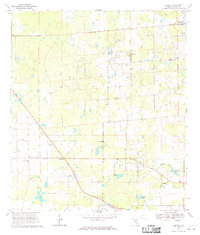
1968 Map of Fairfield
USGS Topo · Published 1970About this map
Fairfield and Blitchton serve as the primary hubs in this north-central Florida landscape, mapped just as modern infrastructure began to overtake the rural citrus and cattle country. Numerous quarries dot the terrain, signaling the importance of the local limestone industry during the late 1960s. The presence of an Old Railroad Grade cutting through the eastern sections hints at earlier timber or mining transport routes that once connected these isolated settlements. For those tracing family histories or early community centers, the map identifies several local landmarks including Pleasant View Ch, New Chapel Ch, and Pine Grove Cem. Small water bodies like Raymer Pond and Peter Gibson Pond anchor the low-lying areas, while the Blitchton Lookout Tower stands as a notable sentinel over the surrounding woodland and fields.
Find a feature on this map
21 named features on this map. Tap any name to fly to it.
Don’t see what you’re looking for? This feature index may not catch every label — zoom into the map to look around manually.
Map Details
Editions of this 1968 Fairfield Map
3 editions found
Other maps of this area

1892 · Dunnellon
USGS Topo · 1:62,500

1893 · Citra
USGS Topo · 1:62,500

1894 · Dunnellon
USGS Topo · 1:62,500

1895 · Williston
USGS Topo · 1:62,500

1895 · Citra
USGS Topo · 1:62,500

1895 · Ocala
USGS Topo · 1:62,500

1954 · Romeo
USGS Topo · 1:24,000

1954 · Cotton Plant
USGS Topo · 1:24,000

1954 · Dunnellon
USGS Topo · 1:62,500

1954 · Gainesville
USGS Topo · 1:250,000