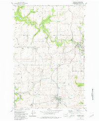
1980 Map of Fairfield
USGS Topo · Published 1980About this map
The agricultural heart of Spokane County is defined by the rail lines and winding waterways of this 1980 survey. Fairfield and Rockford serve as the primary hubs, anchored by extensive Grain Elevator Storage Bins and water infrastructure that signal the area's importance to the regional wheat economy. The landscape is carved by a network of drainage systems including Hangman Creek, Rattler Run, and Rock Creek, while prominent elevations like Morefield Butte and Hansen Butte break the rolling terrain.
Find a feature on this map
39 named features on this map. Tap any name to fly to it.
Don’t see what you’re looking for? This feature index may not catch every label — zoom into the map to look around manually.
Map Details
Editions of this 1980 Fairfield Map
This is the sole edition of this map. No revisions or reprints were ever made.
Other maps of this area

1901 · Spokane
USGS Topo · 1:125,000

1903 · Oakesdale
USGS Topo · 1:125,000

1905 · Oakesdale
USGS Topo · 1:125,000

1949 · Greenacres
USGS Topo · 1:62,500

1950 · Spokane SE
USGS Topo · 1:24,000

1950 · Spokane
USGS Topo · 1:62,500

1951 · Greenacres
USGS Topo · 1:62,500

1954 · Spangle
USGS Topo · 1:62,500

1954 · Fairfield
USGS Topo · 1:62,500

1955 · Spokane
USGS Topo · 1:250,000