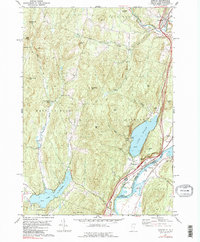
1981 Map of Fairlee
USGS Topo · Published 1990About this map
The Connecticut River serves as the dividing line between Vermont and New Hampshire, anchoring a landscape of glacial lakes and river-bottom agriculture during the early 1980s. The settlement of Fairlee is positioned between the river and the dramatic cliff of The Palisades, while Lake Morey and Lake Fairlee define the region's recreational character. Transportation patterns are clearly visible, with the Boston and Maine railroad following the riverbank parallel to modern highway interchanges.
Find a feature on this map
55 named features on this map. Tap any name to fly to it.
Don’t see what you’re looking for? This feature index may not catch every label — zoom into the map to look around manually.
Map Details
Editions of this 1981 Fairlee Map
3 editions found
Other maps of this area

1896 · Strafford
USGS Topo · 1:62,500

1931 · Mt. Cube
USGS Topo · 1:62,500

1931 · Woodsville
USGS Topo · 1:48,000

1933 · Mt. Cube
USGS Topo · 1:62,500

1935 · Woodsville
USGS Topo · 1:62,500

1941 · Woodsville
USGS Topo · 1:62,500

1944 · Strafford
USGS Topo · 1:62,500

1947 · Corinth
USGS Topo · 1:62,500

1948 · East Barre
USGS Topo · 1:62,500

1950 · Glens Falls
USGS Topo · 1:250,000