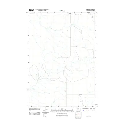
2012 Map of Fairpoint
USGS Topo · Published 2012About this map
Fairpoint is a small unincorporated community in northern Meade County, characterized by its isolation on the expansive South Dakota plains. The settlement centers around the intersection of Fairpoint Rd and Old Stoneville Rd, with the Fairpoint Cem situated just to the northeast of the main cluster of buildings. The landscape is defined by the winding drainage of Coyote Cr, which meanders through the central and southern portions of the quadrangle, carving a low-relief path through the grasslands. The road network, including Red Owl Rd and Co Hwy Mc-22, reflects the essential transport corridors for the ranching and agricultural operations that sustain this part of the state. This 2012 survey documents the persistent, sparsely populated character of the region, where family-named roads like Minnehaha Pl and section-line tracks provide the only interruptions to the open range.
Find a feature on this map
10 named features on this map. Tap any name to fly to it.
Don’t see what you’re looking for? This feature index may not catch every label — zoom into the map to look around manually.
Map Details
Editions of this 2012 Fairpoint Map
This is the sole edition of this map. No revisions or reprints were ever made.
Other maps of this area

1953 · Rapid City
USGS Topo · 1:250,000

1957 · Rapid City
USGS Topo · 1:250,000

1959 · Fairpoint
USGS Topo · 1:24,000

1959 · Fairpoint SW
USGS Topo · 1:24,000

1959 · Stoneville
USGS Topo · 1:24,000

1959 · Union Center
USGS Topo · 1:24,000

1959 · Fairpoint NW
USGS Topo · 1:24,000
1959 · Fairpoint SE
USGS Topo · 1:24,000

1977 · Table Top Butte
USGS Topo · 1:24,000

1978 · Bull Run Creek
USGS Topo · 1:24,000