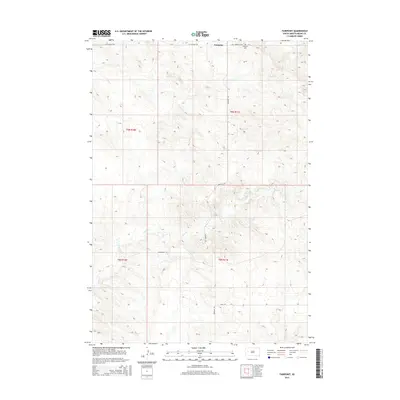
2015 Map of Fairpoint
USGS Topo · Published 2015About this map
Fairpoint serves as a central point in this rural landscape of Meade County, where the topography is defined by the drainage of Coyote Cr. This 2015 survey illustrates a sparsely populated region of South Dakota where the grid of sections is maintained by a network of gravel and dirt routes, including W Fairpoint Rd and Old Stoneville Rd. The presence of the Fairpoint Cem northeast of the settlement provides a localized point of interest for genealogical research, anchoring the history of the families who settled this high plains country. Further south, Minnehaha Pl and Atall Rd branch off from the main thoroughfare, showing the continued occupation and accessibility of these western townships.
Find a feature on this map
12 named features on this map. Tap any name to fly to it.
Don’t see what you’re looking for? This feature index may not catch every label — zoom into the map to look around manually.
Map Details
Editions of this 2015 Fairpoint Map
This is the sole edition of this map. No revisions or reprints were ever made.
Other maps of this area

1953 · Rapid City
USGS Topo · 1:250,000

1957 · Rapid City
USGS Topo · 1:250,000

1959 · Fairpoint
USGS Topo · 1:24,000

1959 · Fairpoint SW
USGS Topo · 1:24,000

1959 · Stoneville
USGS Topo · 1:24,000

1959 · Union Center
USGS Topo · 1:24,000

1959 · Fairpoint NW
USGS Topo · 1:24,000
1959 · Fairpoint SE
USGS Topo · 1:24,000

1977 · Table Top Butte
USGS Topo · 1:24,000

1978 · Bull Run Creek
USGS Topo · 1:24,000