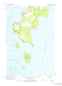
1958 Map of Fairport
USGS Topo · Published 1978About this map
The Garden Peninsula Manistique River State Forest dominates this mid-century look at Michigan's southern Delta County, where the land narrows between Big Bay de Noc and Lake Michigan. Human activity is concentrated along the western shoreline, anchored by the settlement of Fayette and its Fayette P O. Historical traces of community life are evident through sites like St Peters Cem, Hinks Cem, and the Mud Lake Sch.
Find a feature on this map
47 named features on this map. Tap any name to fly to it.
Don’t see what you’re looking for? This feature index may not catch every label — zoom into the map to look around manually.
Map Details
Editions of this 1958 Fairport Map
2 editions found

Other maps of this area

1932 · Burnt Bluff SW
USGS Topo · 1:31,680

1932 · Burnt Bluff NE
USGS Topo · 1:31,680

1932 · Burnt Bluff NW
USGS Topo · 1:31,680

1932 · Garden SE
USGS Topo · 1:31,680

1932 · Rapid River SE
USGS Topo · 1:31,680

1954 · Escanaba
USGS Topo · 1:250,000

1957 · Escanaba
USGS Topo · 1:250,000

1958 · Escanaba
USGS Topo · 1:250,000

1958 · Cooks
USGS Topo · 1:62,500

1958 · Garden
USGS Topo · 1:62,500