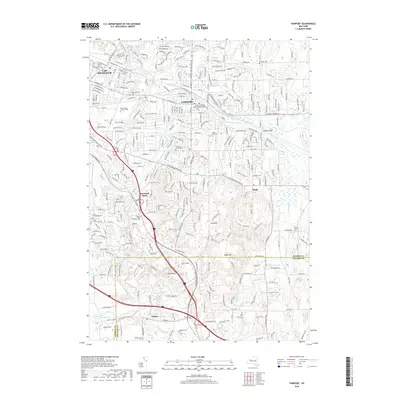
2019 Map of Fairport
USGS Topo · Published 2019About this map
The Erie Canal forms the historical spine of this region, winding through Fairport and beneath Knapps Bridge as it navigates the terrain of eastern Monroe County. This 2019 survey documents the suburban landscape around East Rochester and the outlying settlements of Bushnell Basin and Egypt, where residential expansion meets the distinctive glacial topography of Turk Hill and Baker Hill. Genealogists will find a high concentration of burial grounds, including the Mount Greenvale Pleasant Rural Cem and the Perinton Center Cem. The southern edge of the map tracks the boundary at the Monroe Co and Ontario Co line, near the community of Fishers. Natural drainage patterns like Irondequoit Creek and White Brook contrast with the engineered path of the canal, illustrating how the 19th-century waterway continues to influence modern spatial development.
Find a feature on this map
285 named features on this map. Tap any name to fly to it.
Don’t see what you’re looking for? This feature index may not catch every label — zoom into the map to look around manually.
Map Details
Editions of this 2019 Fairport Map
This is the sole edition of this map. No revisions or reprints were ever made.
Other maps of this area

1895 · Rochester
USGS Topo · 1:62,500

1898 · Rochester
USGS Topo · 1:62,500

1900 · Macedon
USGS Topo · 1:62,500

1900 · Canandaigua
USGS Topo · 1:62,500

1901 · Honeoye
USGS Topo · 1:62,500

1903 · Canandaigua
USGS Topo · 1:62,500

1904 · Honeoye
USGS Topo · 1:62,500

1912 · Rochester
USGS Topo · 1:62,500

1920 · Rochester
USGS Topo · 1:62,500

1931 · Mendon Ponds
USGS Topo · 1:24,000