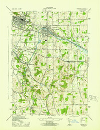
1943 Map of Fairport
USGS Topo · Published 1943About this map
The Barge Canal cuts a distinctive path through this mid-century landscape, anchoring the village of Fairport and shaping the region's industrial and transport character. To the west, East Rochester displays an organized street grid, while the surrounding area is punctuated by specialized landmarks like Radio Station Wham and an Airport. The terrain shifts from the flat canal corridor to the significant elevations of Turk Hill and Turks Hill 2 in the south, where Powder Mill Park and small water bodies like Lily Pond and Lake Lacoma provide a contrast to the agricultural and residential development elsewhere.
Find a feature on this map
71 named features on this map. Tap any name to fly to it.
Don’t see what you’re looking for? This feature index may not catch every label — zoom into the map to look around manually.
Map Details
Editions of this 1943 Fairport Map
This is the sole edition of this map. No revisions or reprints were ever made.
Other maps of this area

1895 · Rochester
USGS Topo · 1:62,500

1898 · Rochester
USGS Topo · 1:62,500

1900 · Macedon
USGS Topo · 1:62,500

1900 · Canandaigua
USGS Topo · 1:62,500

1901 · Honeoye
USGS Topo · 1:62,500

1903 · Canandaigua
USGS Topo · 1:62,500

1904 · Honeoye
USGS Topo · 1:62,500

1912 · Rochester
USGS Topo · 1:62,500

1920 · Rochester
USGS Topo · 1:62,500

1931 · Mendon Ponds
USGS Topo · 1:24,000